IMAGES TAKEN NEAR TO
Overmills Road, AYR, KA7 3LH
Introduction
This page details the photographs taken nearby to Overmills Road, KA7 3LH by members of the Geograph project.
The Geograph project started in 2005 with the aim of publishing, organising and preserving representative images for every square kilometre of Great Britain, Ireland and the Isle of Man.

There are currently over 7.5m images from over14,400 individuals and you can help contribute to the project by visiting https://www.geograph.org.uk
Image Map
Images are licensed for reuse under creativecommons.org/licenses/by-sa/2.0
Notes
- Clicking on the map will re-center to the selected point.
- The higher the marker number, the further away the image location is from the centre of the postcode.
Image Listing (120 Images Found)
Images are licensed for reuse under creativecommons.org/licenses/by-sa/2.0
Image
Details
Distance
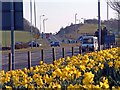
1
Holmston
Photograph taken looking due west looking towards Holmston Ayr with the Arran hills in the background, Dobbies garden centre on the left
Image: © Brian Wotherspoon
Taken: 20 Feb 2005
0.05 miles
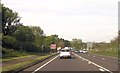
8
A77 South (Holmston Roundabout, Ayr)
Image: © Brian Wotherspoon
Taken: 21 Mar 2003
0.17 miles
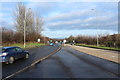
9
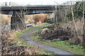
River Ayr Walk
Passing under the A77.
Image: © Billy McCrorie
Taken: 10 Jan 2018
0.17 miles