IMAGES TAKEN NEAR TO
Hillfoot Road, AYR, KA7 3LF
Introduction
This page details the photographs taken nearby to Hillfoot Road, KA7 3LF by members of the Geograph project.
The Geograph project started in 2005 with the aim of publishing, organising and preserving representative images for every square kilometre of Great Britain, Ireland and the Isle of Man.

There are currently over 7.5m images from over14,400 individuals and you can help contribute to the project by visiting https://www.geograph.org.uk
Image Map (Loading...)


Getting Data...Please wait
Leaflet Map data © OpenStreetMap
Images are licensed for reuse under creativecommons.org/licenses/by-sa/2.0
Notes
- Clicking on the map will re-center to the selected point.
- The higher the marker number, the further away the image location is from the centre of the postcode.
Image Listing (23 Images Found)
Images are licensed for reuse under creativecommons.org/licenses/by-sa/2.0
Image
Details
Distance
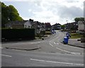
1
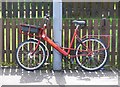
Royal Mail
Revolutionary transport system enables Ayr to reduce its carbon footprint for postal delivery services.
Image: © Andy Farrington
Taken: 14 May 2010
0.03 miles
2

Royal Mail
Postman Pat still gets about in a more traditional fashion in Ayr
Image: © Andy Farrington
Taken: 14 May 2010
0.04 miles


6
Pine Brae
Blue bin day in Pine Brae Ayr
Image: © Andy Farrington
Taken: 14 May 2010
0.09 miles
7

Castlehill Park
Children's play area in Castlehill Park, operated by South Ayrshire Council.
Image: © Mary and Angus Hogg
Taken: 24 Jan 2008
0.13 miles