IMAGES TAKEN NEAR TO
Ellisland Square, AYR, KA7 3ED
Introduction
This page details the photographs taken nearby to Ellisland Square, KA7 3ED by members of the Geograph project.
The Geograph project started in 2005 with the aim of publishing, organising and preserving representative images for every square kilometre of Great Britain, Ireland and the Isle of Man.

There are currently over 7.5m images from over14,400 individuals and you can help contribute to the project by visiting https://www.geograph.org.uk
Image Map
Images are licensed for reuse under creativecommons.org/licenses/by-sa/2.0
Notes
- Clicking on the map will re-center to the selected point.
- The higher the marker number, the further away the image location is from the centre of the postcode.
Image Listing (43 Images Found)
Images are licensed for reuse under creativecommons.org/licenses/by-sa/2.0
Image
Details
Distance
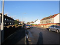
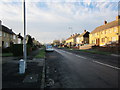
5
Castlehill Road, Ayr
Looking into the town on a fine May morning.
Image: © Mary and Angus Hogg
Taken: 4 May 2007
0.10 miles
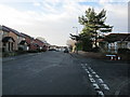
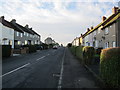
7
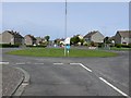
Mount Oliphant Crescent
View along the crescent towards the River Ayr.
Image: © Andy Farrington
Taken: 14 May 2010
0.11 miles
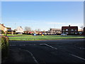
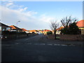
8
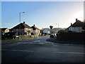
Mount Oliphant Crescent
At the junction with Lochlea Drive.
Image: © Billy McCrorie
Taken: 10 Jan 2013
0.13 miles