IMAGES TAKEN NEAR TO
Lochlea Drive, AYR, KA7 3DS
Introduction
This page details the photographs taken nearby to Lochlea Drive, KA7 3DS by members of the Geograph project.
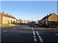
The Geograph project started in 2005 with the aim of publishing, organising and preserving representative images for every square kilometre of Great Britain, Ireland and the Isle of Man.

There are currently over 7.5m images from over14,400 individuals and you can help contribute to the project by visiting https://www.geograph.org.uk
Image Map
Images are licensed for reuse under creativecommons.org/licenses/by-sa/2.0
Notes
- Clicking on the map will re-center to the selected point.
- The higher the marker number, the further away the image location is from the centre of the postcode.
Image Listing (126 Images Found)
Images are licensed for reuse under creativecommons.org/licenses/by-sa/2.0
Image
Details
Distance
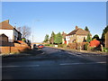
2
Mount Oliphant Crescent
View along the crescent towards the River Ayr.
Image: © Andy Farrington
Taken: 14 May 2010
0.08 miles
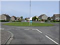
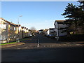
3
Mount Oliphant Crescent
At the junction with Lochlea Drive.
Image: © Billy McCrorie
Taken: 10 Jan 2013
0.09 miles
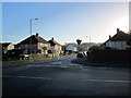
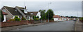
4
Forehill Road
In the vast fields of bungalows on the east side of Ayr.
Image: © Richard Webb
Taken: 13 Aug 2014
0.09 miles
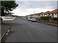
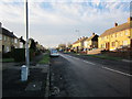
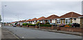
7
Forehill Road
Bungalows on the south side of the road, near Ayr Cemetery.
Image: © Thomas Nugent
Taken: 3 Aug 2018
0.10 miles
9
Forehill Road
Bungalows on the north side of the road, bordering Ayr Cemetery.
Image: © Thomas Nugent
Taken: 3 Aug 2018
0.11 miles
10
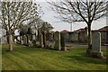
Ayr Cemetery
Some early 20th century graves in Ayr Cemetery. The rooftops of some of the houses in Forehill Road can just be seen behind the wall.
Image: © Richard Sutcliffe
Taken: 10 Apr 2015
0.12 miles