IMAGES TAKEN NEAR TO
Dongola Road, AYR, KA7 3BH
Introduction
This page details the photographs taken nearby to Dongola Road, KA7 3BH by members of the Geograph project.
The Geograph project started in 2005 with the aim of publishing, organising and preserving representative images for every square kilometre of Great Britain, Ireland and the Isle of Man.

There are currently over 7.5m images from over14,400 individuals and you can help contribute to the project by visiting https://www.geograph.org.uk
Image Map
Images are licensed for reuse under creativecommons.org/licenses/by-sa/2.0
Notes
- Clicking on the map will re-center to the selected point.
- The higher the marker number, the further away the image location is from the centre of the postcode.
Image Listing (325 Images Found)
Images are licensed for reuse under creativecommons.org/licenses/by-sa/2.0
Image
Details
Distance
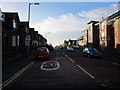
6
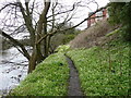
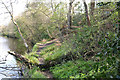
Footpath next to the River Ayr
Footpath next to the River Ayr below the flats on the site of the old Ayr County Hospital.
Image: © David Johnston
Taken: 15 Apr 2008
0.04 miles
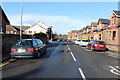
10
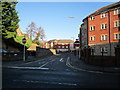
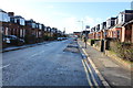
Mill Brae
New houses are built on the site of the old Ayr hospital.
Image: © Billy McCrorie
Taken: 10 Jan 2013
0.06 miles