IMAGES TAKEN NEAR TO
Ashgrove Street, AYR, KA7 3AQ
Introduction
This page details the photographs taken nearby to Ashgrove Street, KA7 3AQ by members of the Geograph project.
The Geograph project started in 2005 with the aim of publishing, organising and preserving representative images for every square kilometre of Great Britain, Ireland and the Isle of Man.

There are currently over 7.5m images from over14,400 individuals and you can help contribute to the project by visiting https://www.geograph.org.uk
Image Map
Images are licensed for reuse under creativecommons.org/licenses/by-sa/2.0
Notes
- Clicking on the map will re-center to the selected point.
- The higher the marker number, the further away the image location is from the centre of the postcode.
Image Listing (333 Images Found)
Images are licensed for reuse under creativecommons.org/licenses/by-sa/2.0
Image
Details
Distance
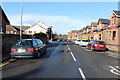
5
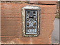
Ordnance Survey Flush Bracket G129
This can be found on the wall of Holmston Primary School in Ayr.
For more detail see : http://www.bench-marks.org.uk/bm113
Image: © Peter Wood
Taken: 12 Sep 2016
0.06 miles
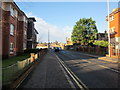
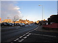
6
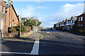
Ashgrove Street
From the Castlehill Road.
Image: © Billy McCrorie
Taken: 10 Jan 2013
0.06 miles
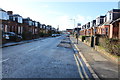
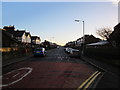
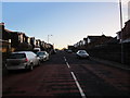
8
Castlehill Road
From the junction with St Andrew's Street.
Image: © Billy McCrorie
Taken: 10 Jan 2013
0.07 miles
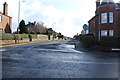
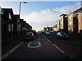
9
St Andrew's Street
From the Castlehill Road.
Image: © Billy McCrorie
Taken: 10 Jan 2013
0.07 miles