IMAGES TAKEN NEAR TO
Racecourse Road, AYR, KA7 2UP
Introduction
This page details the photographs taken nearby to Racecourse Road, KA7 2UP by members of the Geograph project.
The Geograph project started in 2005 with the aim of publishing, organising and preserving representative images for every square kilometre of Great Britain, Ireland and the Isle of Man.

There are currently over 7.5m images from over14,400 individuals and you can help contribute to the project by visiting https://www.geograph.org.uk
Image Map
Images are licensed for reuse under creativecommons.org/licenses/by-sa/2.0
Notes
- Clicking on the map will re-center to the selected point.
- The higher the marker number, the further away the image location is from the centre of the postcode.
Image Listing (134 Images Found)
Images are licensed for reuse under creativecommons.org/licenses/by-sa/2.0
Image
Details
Distance
1
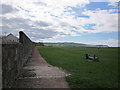
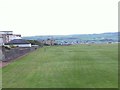
Low Green
Path along the low green with view towards Heads of Ayr on the mid right.
Image: © Billy McCrorie
Taken: 31 Mar 2012
0.07 miles
2
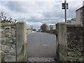
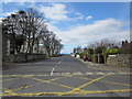
Fairfield Road
Pedestrian access from the low green.
Image: © Billy McCrorie
Taken: 31 Mar 2012
0.07 miles
3
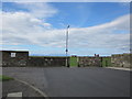
Fairfield Road
End of Fairfield Road with view over to Isle of Arran.
Image: © Billy McCrorie
Taken: 31 Mar 2012
0.08 miles
4
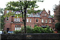
Savoy Park Hotel, Ayr
As you can see it's on Racecourse Road.
Image: © Billy McCrorie
Taken: 4 Sep 2019
0.09 miles
5
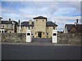
Fairfield House Hotel
Entrance to Hotel on Fairfield Road.
Image: © Billy McCrorie
Taken: 31 Mar 2012
0.09 miles
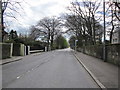
7
Fairfield Road
Taken from Racecourse Road.
Image: © Billy McCrorie
Taken: 31 Mar 2012
0.10 miles
10
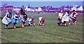
Egg and spoon race on the Low Green, Ayr
Sports on a Sunday school trip to the coast.
Image: © Alan Reid
Taken: Unknown
0.11 miles