IMAGES TAKEN NEAR TO
Carrick Gardens, AYR, KA7 2RT
Introduction
This page details the photographs taken nearby to Carrick Gardens, KA7 2RT by members of the Geograph project.
The Geograph project started in 2005 with the aim of publishing, organising and preserving representative images for every square kilometre of Great Britain, Ireland and the Isle of Man.

There are currently over 7.5m images from over14,400 individuals and you can help contribute to the project by visiting https://www.geograph.org.uk
Image Map
Images are licensed for reuse under creativecommons.org/licenses/by-sa/2.0
Notes
- Clicking on the map will re-center to the selected point.
- The higher the marker number, the further away the image location is from the centre of the postcode.
Image Listing (64 Images Found)
Images are licensed for reuse under creativecommons.org/licenses/by-sa/2.0
Image
Details
Distance
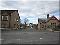
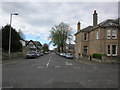
2
Broomfield Road
From the junction with Carrick Road.
Image: © Billy McCrorie
Taken: 31 Mar 2012
0.03 miles
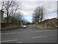
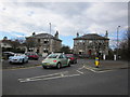
3
Carrick Road
From the junction with St Leonard's Road going in the direction of Ayr town centre.
Image: © Billy McCrorie
Taken: 31 Mar 2012
0.03 miles
4
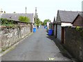
Carrick Road Lane
Blue bin day in Carrick Road Lane Ayr
Image: © Andy Farrington
Taken: 14 May 2010
0.04 miles
5
Carrick Avenue
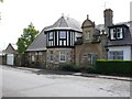
Number 10 is The Gatehouse
Image: © Andy Farrington
Taken: 14 May 2010
0.04 miles
7
Chestnut Tree
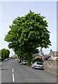
This large tree in Carrick Avenue has clearly been here for some time, the road has been tarmaced around it
Image: © Andy Farrington
Taken: 14 May 2010
0.06 miles
8
Chalmers Road
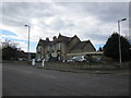
Leads to the T A Centre.
Image: © Billy McCrorie
Taken: 31 Mar 2012
0.06 miles
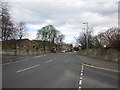
10
St Leonard's Road Junction
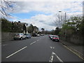
With Monument Road.
Image: © Billy McCrorie
Taken: 31 Mar 2012
0.07 miles