IMAGES TAKEN NEAR TO
Ballantine Drive, AYR, KA7 2RG
Introduction
This page details the photographs taken nearby to Ballantine Drive, KA7 2RG by members of the Geograph project.
The Geograph project started in 2005 with the aim of publishing, organising and preserving representative images for every square kilometre of Great Britain, Ireland and the Isle of Man.

There are currently over 7.5m images from over14,400 individuals and you can help contribute to the project by visiting https://www.geograph.org.uk
Image Map
Images are licensed for reuse under creativecommons.org/licenses/by-sa/2.0
Notes
- Clicking on the map will re-center to the selected point.
- The higher the marker number, the further away the image location is from the centre of the postcode.
Image Listing (89 Images Found)
Images are licensed for reuse under creativecommons.org/licenses/by-sa/2.0
Image
Details
Distance
1
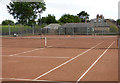
Carrick Lawn Tennis Club
Four red blaes courts and pavilion on Ballantine Drive.
Club web site: https://clubspark.lta.org.uk/AyrCarrickLTC .
Image: © Thomas Nugent
Taken: 3 Aug 2018
0.05 miles
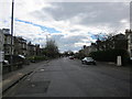
3
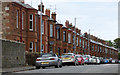
Ballantine Drive
Red sandstone terraced houses overlooking the tennis courts.
Image: © Thomas Nugent
Taken: 3 Aug 2018
0.06 miles
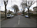
4
Carrick Road
In the direction of Ayr town centre.
Image: © Billy McCrorie
Taken: 31 Mar 2012
0.08 miles
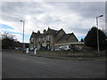
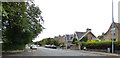
5

Carrick Road at Carrick Lodge Hotel
Image: © Darrin Antrobus
Taken: 15 Aug 2010
0.08 miles
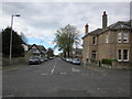
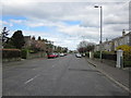
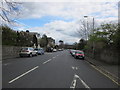
7
Carrick Road
At the junction with Ballantine Drive.
Image: © Thomas Nugent
Taken: 3 Aug 2018
0.09 miles
8
Chalmers Road
Leads to the T A Centre.
Image: © Billy McCrorie
Taken: 31 Mar 2012
0.11 miles