IMAGES TAKEN NEAR TO
Ewenfield Road, AYR, KA7 2QD
Introduction
This page details the photographs taken nearby to Ewenfield Road, KA7 2QD by members of the Geograph project.
The Geograph project started in 2005 with the aim of publishing, organising and preserving representative images for every square kilometre of Great Britain, Ireland and the Isle of Man.

There are currently over 7.5m images from over14,400 individuals and you can help contribute to the project by visiting https://www.geograph.org.uk
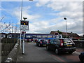
Image Map
Images are licensed for reuse under creativecommons.org/licenses/by-sa/2.0
Notes
- Clicking on the map will re-center to the selected point.
- The higher the marker number, the further away the image location is from the centre of the postcode.
Image Listing (32 Images Found)
Images are licensed for reuse under creativecommons.org/licenses/by-sa/2.0
Image
Details
Distance
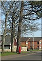
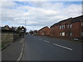
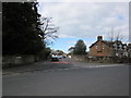
3
Ewenfield Avenue
From the junction with Ewenfield Road.
Image: © Billy McCrorie
Taken: 31 Mar 2012
0.04 miles
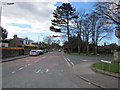
5
St Leonard's Road
From the junction at Ewenfield Road.
Image: © Billy McCrorie
Taken: 31 Mar 2012
0.06 miles
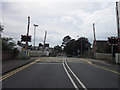
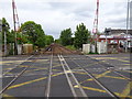
6
Belmont Crossing
Train heading for Maybole and Girvan.
Image: © Billy McCrorie
Taken: 31 Mar 2012
0.07 miles
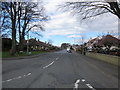
7
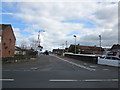
Belmont Road
Looking towards the Railway Crossing on Belmont Road.
Image: © Billy McCrorie
Taken: 31 Mar 2012
0.07 miles
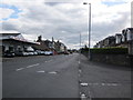
9
The Ayr-Stranraer railway line at Belmont Rd LC in Ayr
Image: © Nigel Thompson
Taken: 9 May 2019
0.09 miles
10
Bellevale Avenue
From the junction with St Leonard's Road.
Image: © Billy McCrorie
Taken: 31 Mar 2012
0.09 miles