IMAGES TAKEN NEAR TO
Wellington Lane, AYR, KA7 2DA
Introduction
This page details the photographs taken nearby to Wellington Lane, KA7 2DA by members of the Geograph project.
The Geograph project started in 2005 with the aim of publishing, organising and preserving representative images for every square kilometre of Great Britain, Ireland and the Isle of Man.

There are currently over 7.5m images from over14,400 individuals and you can help contribute to the project by visiting https://www.geograph.org.uk
Image Map
Images are licensed for reuse under creativecommons.org/licenses/by-sa/2.0
Notes
- Clicking on the map will re-center to the selected point.
- The higher the marker number, the further away the image location is from the centre of the postcode.
Image Listing (457 Images Found)
Images are licensed for reuse under creativecommons.org/licenses/by-sa/2.0
Image
Details
Distance
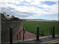
1
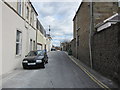
Wellington Lane
Leading up to Alloway Place.
Image: © Billy McCrorie
Taken: 31 Mar 2012
0.01 miles
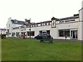
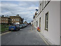
2
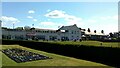
Golden Disc Fun Centre, Wellington Lane, Ayr
Image: © Stephen Armstrong
Taken: 25 Apr 2023
0.02 miles
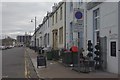
3
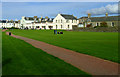
Low Green
Looking towards the Golden Disc family entertainment centre.
Image: © Thomas Nugent
Taken: 22 Sep 2012
0.02 miles
5
Low Green
Start of the path from Wellington Lane.
Image: © Billy McCrorie
Taken: 31 Mar 2012
0.02 miles
6
Wellington Lane
Going towards Wellington Square Gardens.
Image: © Billy McCrorie
Taken: 31 Mar 2012
0.03 miles
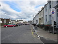
7
Wellington Square, Ayr
Looking along the south side of the square.
Image: © Stephen McKay
Taken: 21 Mar 2012
0.03 miles
8
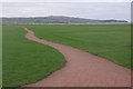
Low Green, Ayr
A sinuous path crosses this open space backing the beach.
Image: © Stephen McKay
Taken: 21 Mar 2012
0.03 miles
10
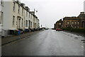
Wellington Square, Ayr
Leading onto Pavilion Road.
Image: © Billy McCrorie
Taken: 30 Sep 2020
0.04 miles