IMAGES TAKEN NEAR TO
Fairfield Park, AYR, KA7 2AT
Introduction
This page details the photographs taken nearby to Fairfield Park, KA7 2AT by members of the Geograph project.
The Geograph project started in 2005 with the aim of publishing, organising and preserving representative images for every square kilometre of Great Britain, Ireland and the Isle of Man.

There are currently over 7.5m images from over14,400 individuals and you can help contribute to the project by visiting https://www.geograph.org.uk
Image Map
Images are licensed for reuse under creativecommons.org/licenses/by-sa/2.0
Notes
- Clicking on the map will re-center to the selected point.
- The higher the marker number, the further away the image location is from the centre of the postcode.
Image Listing (120 Images Found)
Images are licensed for reuse under creativecommons.org/licenses/by-sa/2.0
Image
Details
Distance
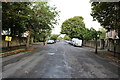
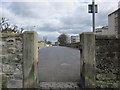
2
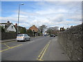
Fairfield Road
Taken from Racecourse Road.
Image: © Billy McCrorie
Taken: 31 Mar 2012
0.03 miles
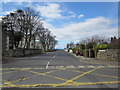
3
Alloway Place
T junction where Alloway Place, Miller Road and Racecourse Road meet.
Image: © Billy McCrorie
Taken: 31 Mar 2012
0.06 miles
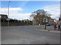
4
Racecourse Road
After traffic lights becomes Alloway Place.
Image: © Billy McCrorie
Taken: 31 Mar 2012
0.06 miles

6
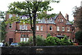
Savoy Park Hotel, Ayr
As you can see it's on Racecourse Road.
Image: © Billy McCrorie
Taken: 4 Sep 2019
0.09 miles
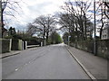
7
Miller Road
From the junction with Barns Crescent.
Image: © Billy McCrorie
Taken: 31 Mar 2012
0.09 miles
8
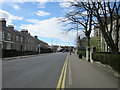
Racecourse Road, Ayr
Heading for the town centre.
Image: © Billy McCrorie
Taken: 4 Sep 2019
0.09 miles
9
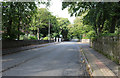
Fairfield Road
Pedestrian access from the low green.
Image: © Billy McCrorie
Taken: 31 Mar 2012
0.09 miles