IMAGES TAKEN NEAR TO
Trenchard Court, AYR, KA7 1JU
Introduction
This page details the photographs taken nearby to Trenchard Court, KA7 1JU by members of the Geograph project.
The Geograph project started in 2005 with the aim of publishing, organising and preserving representative images for every square kilometre of Great Britain, Ireland and the Isle of Man.

There are currently over 7.5m images from over14,400 individuals and you can help contribute to the project by visiting https://www.geograph.org.uk
Image Map
Images are licensed for reuse under creativecommons.org/licenses/by-sa/2.0
Notes
- Clicking on the map will re-center to the selected point.
- The higher the marker number, the further away the image location is from the centre of the postcode.
Image Listing (325 Images Found)
Images are licensed for reuse under creativecommons.org/licenses/by-sa/2.0
Image
Details
Distance
1
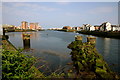
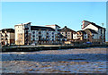
View of Ayr Harbour
Looking towards the town.
Image: © Anthony O'Neil
Taken: 2 Aug 2014
0.02 miles
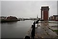
3
A View From The Old Citadel
Looking out across Ayr harbour from the corner of the old citadel walls. Miller's Folly is shown on the right. The flats on both sides of the river are recent additions, coming after the demise of the fish market. The Port of Ayr Arran Terminal is visible in the background.
Image: © Mary and Angus Hogg
Taken: 6 Mar 2009
0.03 miles
4
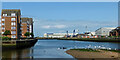
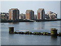
Ayr Harbour
View of the new development in the harbour area
Image: © George Rankin
Taken: 5 May 2007
0.04 miles
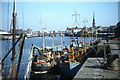
5
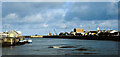
Ayr Harbour June 2021
The harbour has been transformed since the 1971 shot was taken. The fishing fleet now lands its catch in Troon, leaving the old fish quay available for waterfront flats. The Coal Basin, which is still active, now holds the Port of Ayr Kintyre Terminal. Ailsa Craig Terminal lies further up-river on the right-hand side of this view followed by more flats. For the same view 50 years ago, see Image
Image: © Mary and Angus Hogg
Taken: 17 Jun 2021
0.04 miles
6
Ayr Harbour June 1971
This shot of Ayr Harbour was taken in June 1971. The South Harbour, on the left-hand side of this shot, accommodated the fishing fleet. The large grey shed was the fish market. The ice-making plant was housed in the tall white building behind it. The Coal Basin in the central background had no buildings at all in 1971, while the North Harbour held a mixture of small-scale commercial properties. 50 years on, the view looks like Image
Image: © Mary and Angus Hogg
Taken: Unknown
0.04 miles
7
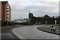
Road from the Citadel Leisure Centre
Image: © Billy McCrorie
Taken: 25 Nov 2016
0.06 miles
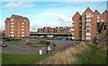
8
Ayr's South Harbour
These modern flats are situated close to the River in Ayr's South Harbour. The tall block on the far right is the Churchill Tower, named after the barracks which formerly occupied this site. Viewed at high tide with the water driven in by a strong north-west wind.
Image: © Mary and Angus Hogg
Taken: 20 Nov 2013
0.06 miles
9
Harbour Development
South harbour. Not a boat in sight!
Image: © wfmillar
Taken: 31 Mar 2007
0.06 miles