IMAGES TAKEN NEAR TO
Marlborough Court, AYR, KA7 1HE
Introduction
This page details the photographs taken nearby to Marlborough Court, KA7 1HE by members of the Geograph project.
The Geograph project started in 2005 with the aim of publishing, organising and preserving representative images for every square kilometre of Great Britain, Ireland and the Isle of Man.

There are currently over 7.5m images from over14,400 individuals and you can help contribute to the project by visiting https://www.geograph.org.uk
Image Map
Images are licensed for reuse under creativecommons.org/licenses/by-sa/2.0
Notes
- Clicking on the map will re-center to the selected point.
- The higher the marker number, the further away the image location is from the centre of the postcode.
Image Listing (564 Images Found)
Images are licensed for reuse under creativecommons.org/licenses/by-sa/2.0
Image
Details
Distance
1
Ayr fish quay 1970
Ayr South Harbour was a busy fishing port in 1970 when this shot was taken. Ivan Boardley was a well-known name in fish marketing and distribution, handling the old-style wooden fish boxes that are shown piled up on the quayside.
Image: © Mary and Angus Hogg
Taken: Unknown
0.01 miles
2
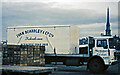
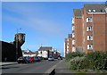
South Harbour Street, Ayr, South Ayrshire
The road to the right leads to the Citadel Leisure Centre.
Miller’s Folly is on the right.
Image: © Mark S
Taken: 17 Aug 2019
0.02 miles
4
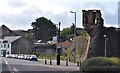
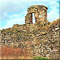
Cromwell's Citadel - Ayr
Miller's Folly
Miller's Folly is part of the original citadel, built by the Cromwellian army in 1652-3. The area later became known as Montgomeriestoun, which was made a Burgh of Barony in 1663.
The successful Ayr businessman, John Miller, bought the property and called himself "Baron Miller". He built the small tower shown in this photograph, though nothing like it had been included in the original citadel. After completion, he seldom looked at the tower, and local people named it "Miller's Folly". (Source: "Ayr Stories", by Dane Love).
Image: © Raibeart MacAoidh
Taken: 9 Feb 2018
0.02 miles
5
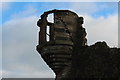
Miller's Folly - Ayr
Miller's Folly is part of the original citadel, built by the Cromwellian army in 1652-3. The area later became known as Montgomeriestoun, which was made a Burgh of Barony in 1663.
The successful Ayr businessman, John Miller, bought the property and called himself "Baron Miller". He built the small tower shown in this photograph, though nothing like it had been included in the original citadel. After completion, he seldom looked at the tower, and local people named it 'Miller's Folly'. (Source: Ayr Stories, by Dane Love)
Image: © Raibeart MacAoidh
Taken: 9 Feb 2018
0.02 miles
6
Harbour Development
South harbour. Not a boat in sight!
Image: © wfmillar
Taken: 31 Mar 2007
0.02 miles
7
Harbour Street, Ayr
Looking towards the sea on a bright March day. The flats on the right are built on the old fish market site. The tower on the left is Miller's Folly, an addition to the old Cromwellian citadel walls. For more information, see Image
Image: © Mary and Angus Hogg
Taken: 6 Mar 2009
0.03 miles
9
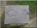
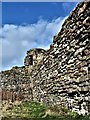
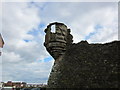
Cromwell's Citadel
Citadel Wall and Miller's Folly history.
Image: © Billy McCrorie
Taken: 31 Mar 2012
0.03 miles
10

Ayr Citadel
Built 1652-54 by the English. Check this http://www.scotwars.com/Ayr_citadel.htm for detailed information about the citadel.
Image: © Thomas Nugent
Taken: 22 Sep 2012
0.03 miles