IMAGES TAKEN NEAR TO
Fort Street, AYR, KA7 1DH
Introduction
This page details the photographs taken nearby to Fort Street, KA7 1DH by members of the Geograph project.
The Geograph project started in 2005 with the aim of publishing, organising and preserving representative images for every square kilometre of Great Britain, Ireland and the Isle of Man.

There are currently over 7.5m images from over14,400 individuals and you can help contribute to the project by visiting https://www.geograph.org.uk
Image Map
Images are licensed for reuse under creativecommons.org/licenses/by-sa/2.0
Notes
- Clicking on the map will re-center to the selected point.
- The higher the marker number, the further away the image location is from the centre of the postcode.
Image Listing (684 Images Found)
Images are licensed for reuse under creativecommons.org/licenses/by-sa/2.0
Image
Details
Distance
1
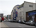
Fort Street, Ayr, South Ayrshire
The view from Cecchini’s on Fort Street.
Image: © Mark S
Taken: 28 Sep 2019
0.01 miles
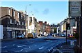
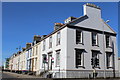
3
Fort Street leading to Alloway Place, Ayr
Image: © Billy McCrorie
Taken: 5 May 2017
0.01 miles
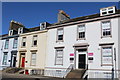
4
Corner of Wellington Square & Fort Street, Ayr
Image: © Leslie Barrie
Taken: 21 Mar 2015
0.02 miles
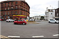
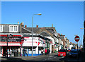
7
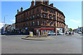
Roundabout at Ayr
Separating Fullarton street, Fort street and the Sandgate.
Image: © Billy McCrorie
Taken: 5 May 2017
0.02 miles
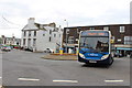
8
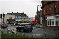
Stagecoach Bus, Ayr
Bus between Fort Street and the Sandgate.
Image: © Billy McCrorie
Taken: 30 Sep 2020
0.02 miles
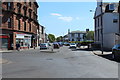
9
Sandgate, Ayr
Southern end of the Sandgate, now part of Ayr's one-way system
Image: © Mary and Angus Hogg
Taken: 9 Oct 2006
0.02 miles