IMAGES TAKEN NEAR TO
Merrick Drive, AYR, KA6 7TJ
Introduction
This page details the photographs taken nearby to Merrick Drive, KA6 7TJ by members of the Geograph project.
The Geograph project started in 2005 with the aim of publishing, organising and preserving representative images for every square kilometre of Great Britain, Ireland and the Isle of Man.

There are currently over 7.5m images from over14,400 individuals and you can help contribute to the project by visiting https://www.geograph.org.uk
Image Map
Images are licensed for reuse under creativecommons.org/licenses/by-sa/2.0
Notes
- Clicking on the map will re-center to the selected point.
- The higher the marker number, the further away the image location is from the centre of the postcode.
Image Listing (2 Images Found)
Images are licensed for reuse under creativecommons.org/licenses/by-sa/2.0
Image
Details
Distance
1
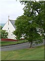
Old tree by new church
Dalmellington Parish Church, a 1950s building in the Bellsbank area, south of the town centre.
Image: © James Allan
Taken: 8 Jun 2007
0.07 miles
2

The drive which leads to Craigengillan House.
This drive leads from the A713 to Craigengillan House. It is over 3 kilometres long.
Image: © Ann Cook
Taken: 22 Apr 2009
0.22 miles