IMAGES TAKEN NEAR TO
Hopes Avenue, AYR, KA6 7RW
Introduction
This page details the photographs taken nearby to Hopes Avenue, KA6 7RW by members of the Geograph project.
The Geograph project started in 2005 with the aim of publishing, organising and preserving representative images for every square kilometre of Great Britain, Ireland and the Isle of Man.

There are currently over 7.5m images from over14,400 individuals and you can help contribute to the project by visiting https://www.geograph.org.uk
Image Map
Images are licensed for reuse under creativecommons.org/licenses/by-sa/2.0
Notes
- Clicking on the map will re-center to the selected point.
- The higher the marker number, the further away the image location is from the centre of the postcode.
Image Listing (65 Images Found)
Images are licensed for reuse under creativecommons.org/licenses/by-sa/2.0
Image
Details
Distance
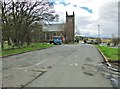
4
Knowehead Road
The road passing Dalmellinton Parish Church on the left.
Image: © Billy McCrorie
Taken: 4 Jan 2012
0.10 miles
5

Dalmellington from the air
Looking southwest en route south from Prestwick.
Image: © M J Richardson
Taken: 25 Aug 2013
0.11 miles
6

Ordnance Survey Flush Bracket G620
This can be found on the wall of the Parish Church.
For more detail see : http://www.bench-marks.org.uk/bm11293
Image: © Peter Wood
Taken: 25 Sep 2013
0.11 miles
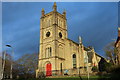
7
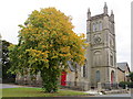
Dalmellington Parish Church
Viewed from the north.
Image: © Peter Wood
Taken: 25 Sep 2013
0.11 miles