IMAGES TAKEN NEAR TO
Craigmark Wynd, AYR, KA6 7RQ
Introduction
This page details the photographs taken nearby to Craigmark Wynd, KA6 7RQ by members of the Geograph project.
The Geograph project started in 2005 with the aim of publishing, organising and preserving representative images for every square kilometre of Great Britain, Ireland and the Isle of Man.

There are currently over 7.5m images from over14,400 individuals and you can help contribute to the project by visiting https://www.geograph.org.uk
Image Map
Images are licensed for reuse under creativecommons.org/licenses/by-sa/2.0
Notes
- Clicking on the map will re-center to the selected point.
- The higher the marker number, the further away the image location is from the centre of the postcode.
Image Listing (10 Images Found)
Images are licensed for reuse under creativecommons.org/licenses/by-sa/2.0
Image
Details
Distance
4
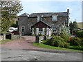
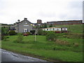
The Craigmark, Dalmellington
This was the shop for the mining settlement of Craigmark. Now it is a pub-restaurant, with some interesting local history notes available.
Image: © Humphrey Bolton
Taken: 22 Sep 2011
0.18 miles
6
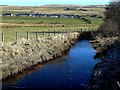
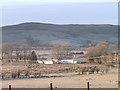
Towards Burnton
Looking towards the houses at Burnton, near Dalmellington, from the wonderfully-named Sillyhole Bridge. The hill in the background is an open-cast mining site.
Image: © Mary and Angus Hogg
Taken: 18 Mar 2011
0.21 miles
7
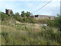
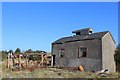
Mine buildings, Craigmark
This was an ironstone mine.
Image: © Humphrey Bolton
Taken: 22 Sep 2011
0.22 miles
8
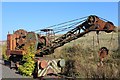
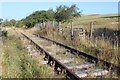
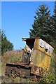
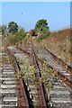
Crane on disused railway at Craigmark
Image: © Leslie Barrie
Taken: 21 Sep 2014
0.22 miles
9
Craigmark
A view to the northeast past the Craigmark public house to the red brick buildings of the former site of the Scottish Industrial Railway Centre. The exhibits moved to the museum complex at Dunaskin in 2004. Visit http://www.dunaskin.co.uk for more information.
Image: © Phil Williams
Taken: 26 May 2006
0.23 miles
10
Sillyhole Farm
Winter view of Sillyhole Farm, with Doe's Loch and Auchenroy hill as a backdrop.
Image: © Davie McClure
Taken: 5 Mar 2008
0.24 miles