IMAGES TAKEN NEAR TO
Dalrymple, AYR, KA6 7HU
Introduction
This page details the photographs taken nearby to KA6 7HU by members of the Geograph project.
The Geograph project started in 2005 with the aim of publishing, organising and preserving representative images for every square kilometre of Great Britain, Ireland and the Isle of Man.

There are currently over 7.5m images from over14,400 individuals and you can help contribute to the project by visiting https://www.geograph.org.uk
Image Map
Images are licensed for reuse under creativecommons.org/licenses/by-sa/2.0
Notes
- Clicking on the map will re-center to the selected point.
- The higher the marker number, the further away the image location is from the centre of the postcode.
Image Listing (6 Images Found)
Images are licensed for reuse under creativecommons.org/licenses/by-sa/2.0
Image
Details
Distance
1
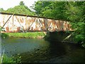
Bridge Over The River Doon
Not the most attractive of bridges, but functional for vehicles up to 10 Tonnes. For a different view of this bridge, see Image
Image: © Mary and Angus Hogg
Taken: 29 May 2008
0.08 miles
3
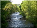
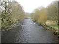
River Doon
Looking upstream, on the very edge of the square. To see this view at a different time of year, see Image
Image: © Mary and Angus Hogg
Taken: 29 May 2008
0.08 miles
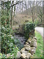
5
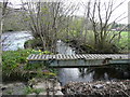
The end of Skeldon Mill Lade
The end of Skeldon mill lade where it joins the river doon.
Image: © David Johnston
Taken: 29 Apr 2010
0.17 miles