IMAGES TAKEN NEAR TO
Hollybush, AYR, KA6 7ED
Introduction
This page details the photographs taken nearby to KA6 7ED by members of the Geograph project.
The Geograph project started in 2005 with the aim of publishing, organising and preserving representative images for every square kilometre of Great Britain, Ireland and the Isle of Man.

There are currently over 7.5m images from over14,400 individuals and you can help contribute to the project by visiting https://www.geograph.org.uk
Image Map
Images are licensed for reuse under creativecommons.org/licenses/by-sa/2.0
Notes
- Clicking on the map will re-center to the selected point.
- The higher the marker number, the further away the image location is from the centre of the postcode.
Image Listing (1 Images Found)
Images are licensed for reuse under creativecommons.org/licenses/by-sa/2.0
Image
Details
Distance
1
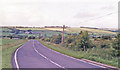
Northward on A713 near site of Holehouse Junction station, 1998
In the Doon Valley, the ex-G&SW line from Ayr to Dalmellington was out of sight on the right here, being still in existence although closed to passengers since 6/4/64; a branch (closed 2/11/59, passengers 3/4/50) went off NE from Holehouse Junction to Belston Junction and Ochiltree, the station having been an 'Exchange Platform' only and closed 3/4/50. The hill ahead is the Crags of Kyle (799 ft.) (Cf. Image]).
Image: © Ben Brooksbank
Taken: 24 Jun 1998
0.18 miles