IMAGES TAKEN NEAR TO
Henrys Place, AYR, KA6 6NB
Introduction
This page details the photographs taken nearby to Henrys Place, KA6 6NB by members of the Geograph project.
The Geograph project started in 2005 with the aim of publishing, organising and preserving representative images for every square kilometre of Great Britain, Ireland and the Isle of Man.

There are currently over 7.5m images from over14,400 individuals and you can help contribute to the project by visiting https://www.geograph.org.uk
Image Map (Loading...)


Getting Data...Please wait
Leaflet Map data © OpenStreetMap
Images are licensed for reuse under creativecommons.org/licenses/by-sa/2.0
Notes
- Clicking on the map will re-center to the selected point.
- The higher the marker number, the further away the image location is from the centre of the postcode.
Image Listing (9 Images Found)
Images are licensed for reuse under creativecommons.org/licenses/by-sa/2.0
Image
Details
Distance
1
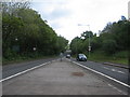
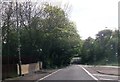
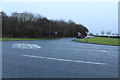
The A70 at Coalhall
A view looking east along the A70 at Coalhall, towards the bridge carrying the railway line over the road.
Image: © Phil Williams
Taken: 24 May 2006
0.20 miles
3
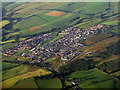
Drongan from the air
An East Ayrshire village and farmland seen in early morning light.
Image: © M J Richardson
Taken: 25 Aug 2013
0.22 miles
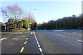
4
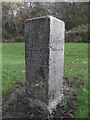
Old Guide Stone by the A70, Coalhall
Square granite by the A70, in parish of Ochiltree (Kyle District), Coalhall, junction with the B730, East of railway bridge.
Surveyed
Milestone Society National ID: AYE_AYCMch.
Image: © Milestone Society
Taken: Unknown
0.23 miles
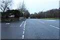
5
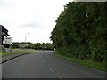
Junction of the B730 and the A70 at Coalhall
Image: © Elliott Simpson
Taken: 5 Aug 2018
0.24 miles