IMAGES TAKEN NEAR TO
Hollybush, AYR, KA6 6EX
Introduction
This page details the photographs taken nearby to KA6 6EX by members of the Geograph project.
The Geograph project started in 2005 with the aim of publishing, organising and preserving representative images for every square kilometre of Great Britain, Ireland and the Isle of Man.

There are currently over 7.5m images from over14,400 individuals and you can help contribute to the project by visiting https://www.geograph.org.uk
Image Map
Images are licensed for reuse under creativecommons.org/licenses/by-sa/2.0
Notes
- Clicking on the map will re-center to the selected point.
- The higher the marker number, the further away the image location is from the centre of the postcode.
Image Listing (2 Images Found)
Images are licensed for reuse under creativecommons.org/licenses/by-sa/2.0
Image
Details
Distance
1
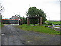
Benston Smithy
A view looking to the southeast towards the A713 from the forecourt of the former filling station at Benston Smithy.
Image: © Phil Williams
Taken: 26 May 2006
0.08 miles
2
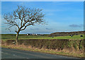
Farmland View
Grazing land viewed from the A713 near Hollybush. Benston Farm, in the next square, is shown in the background. The rolling nature of the land was produced by drumlins, laid down during the last Ice Age.
Image: © Mary and Angus Hogg
Taken: 17 Feb 2013
0.24 miles