IMAGES TAKEN NEAR TO
Glebe Cottages, AYR, KA6 6DP
Introduction
This page details the photographs taken nearby to Glebe Cottages, KA6 6DP by members of the Geograph project.
The Geograph project started in 2005 with the aim of publishing, organising and preserving representative images for every square kilometre of Great Britain, Ireland and the Isle of Man.

There are currently over 7.5m images from over14,400 individuals and you can help contribute to the project by visiting https://www.geograph.org.uk
Image Map
Images are licensed for reuse under creativecommons.org/licenses/by-sa/2.0
Notes
- Clicking on the map will re-center to the selected point.
- The higher the marker number, the further away the image location is from the centre of the postcode.
Image Listing (107 Images Found)
Images are licensed for reuse under creativecommons.org/licenses/by-sa/2.0
Image
Details
Distance
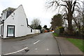
1

Garden street (B7034), Dalrymple
The Kirkton Inn visible at the end of the road has ceased operating.
Image: © Dan
Taken: 3 Feb 2009
0.04 miles
2

Garden Street, Dalrymple
This is the B7034.
Image: © Humphrey Bolton
Taken: 9 Sep 2010
0.05 miles
3

Garden Street
Characterful and characteristic houses along Garden Street, Dalrymple.
Image: © Jonathan Wilkins
Taken: 21 May 2018
0.05 miles
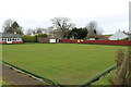
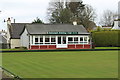
5
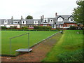
Bowling Green and houses on Garden Street, Dalrymple
Three different types of dormer window.
Image: © Humphrey Bolton
Taken: 10 Oct 2017
0.07 miles