IMAGES TAKEN NEAR TO
Dalrymple, AYR, KA6 6BD
Introduction
This page details the photographs taken nearby to KA6 6BD by members of the Geograph project.
The Geograph project started in 2005 with the aim of publishing, organising and preserving representative images for every square kilometre of Great Britain, Ireland and the Isle of Man.

There are currently over 7.5m images from over14,400 individuals and you can help contribute to the project by visiting https://www.geograph.org.uk
Image Map
Images are licensed for reuse under creativecommons.org/licenses/by-sa/2.0
Notes
- Clicking on the map will re-center to the selected point.
- The higher the marker number, the further away the image location is from the centre of the postcode.
Image Listing (106 Images Found)
Images are licensed for reuse under creativecommons.org/licenses/by-sa/2.0
Image
Details
Distance
2
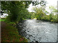
The River Doon, Dalrymple
Taken from the riverside footpath.
Image: © Humphrey Bolton
Taken: 10 Oct 2017
0.04 miles
4
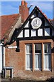
House with Clock, Main Street, Dalrymple
Image: © Leslie Barrie
Taken: 29 Sep 2013
0.12 miles
7
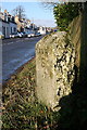
Milestone, Dalrymple
Under the legible Ayr 6 is the less (in this picture) legible Culroy 5 (miles).
Image: © Dan
Taken: 3 Feb 2009
0.12 miles
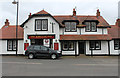
8
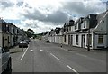
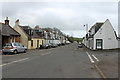
Main Street, Dalrymple
This is the B742.
Image: © Humphrey Bolton
Taken: 9 Sep 2010
0.12 miles
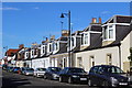
9
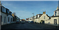
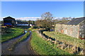
The edge of Dalrymple
Dalrymple is one of the larger villages in this area.
Image: © Malcolm Neal
Taken: 18 Mar 2022
0.12 miles