IMAGES TAKEN NEAR TO
AYR, KA6 5JU
Introduction
This page details the photographs taken nearby to KA6 5JU by members of the Geograph project.
The Geograph project started in 2005 with the aim of publishing, organising and preserving representative images for every square kilometre of Great Britain, Ireland and the Isle of Man.

There are currently over 7.5m images from over14,400 individuals and you can help contribute to the project by visiting https://www.geograph.org.uk
Image Map
Images are licensed for reuse under creativecommons.org/licenses/by-sa/2.0
Notes
- Clicking on the map will re-center to the selected point.
- The higher the marker number, the further away the image location is from the centre of the postcode.
Image Listing (7 Images Found)
Images are licensed for reuse under creativecommons.org/licenses/by-sa/2.0
Image
Details
Distance
1
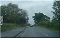
Going east on the A70
A very dull day as we head out for lunch.
Image: © Malcolm Neal
Taken: 22 Sep 2022
0.05 miles
3
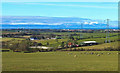
Arran View
A fine view of central Ayrshire's farmland with a snow-capped island of Arran in the far distance.
Image: © Mary and Angus Hogg
Taken: 7 Mar 2016
0.18 miles
5
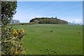
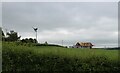
Millcraig Mount
A wooded hilltop to the east of Ayr. A road runs around the outside of the roundel on this side.
Image: © Richard Webb
Taken: 22 Apr 2017
0.20 miles
6
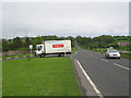
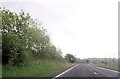
A70 at Carbieston Byres
A view looking to the southeast along the A70 towards Coylton, at the junction with the access roads to Sundrum Castle Holiday Park (left) and Carbieston Byres (right).
Image: © Phil Williams
Taken: 22 May 2006
0.24 miles
7
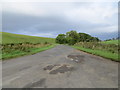
A now by-passed stretch of the formerA70 road
Looking north-westward
Image: © Peter Wood
Taken: 12 Sep 2016
0.25 miles