IMAGES TAKEN NEAR TO
McEwan Crescent, AYR, KA6 5DR
Introduction
This page details the photographs taken nearby to McEwan Crescent, KA6 5DR by members of the Geograph project.
The Geograph project started in 2005 with the aim of publishing, organising and preserving representative images for every square kilometre of Great Britain, Ireland and the Isle of Man.

There are currently over 7.5m images from over14,400 individuals and you can help contribute to the project by visiting https://www.geograph.org.uk
Image Map
Images are licensed for reuse under creativecommons.org/licenses/by-sa/2.0
Notes
- Clicking on the map will re-center to the selected point.
- The higher the marker number, the further away the image location is from the centre of the postcode.
Image Listing (7 Images Found)
Images are licensed for reuse under creativecommons.org/licenses/by-sa/2.0
Image
Details
Distance
1
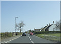
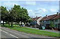
A minor road junction
The junction just visible on the left is a minor road that goes to Drumley Farm,
Image: © Malcolm Neal
Taken: 9 Apr 2019
0.13 miles
2
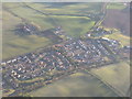
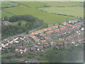
Mossblown Roadend and Townhead
Recent eastern expansion of the village.
Image: © M J Richardson
Taken: 15 Apr 2012
0.14 miles
3
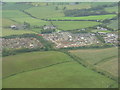
Roadhead at Mossblown
New housebuilding at the east end of the village, with Townhead farm and Afton Park beyond. Seen en route to Prestwick Airport.
Image: © M J Richardson
Taken: 20 Jul 2011
0.19 miles
4
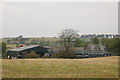
Farmland at Townhead, Mossblown, Ayrshire
This photo was taken from the B743 near Mossblown, Ayrshire.
Image: © L J Cunningham
Taken: 5 Oct 2005
0.21 miles
5
Whiskeyhall View
Looking across the Tarbolton road towards the wonderfully named Whiskeyhall on the edge of Mossblown village.
Image: © Mary and Angus Hogg
Taken: 31 Aug 2013
0.22 miles
6
Mossblown
With Drumley House in the trees to the left. As seen on approach to Prestwick Airport.
Image: © M J Richardson
Taken: 20 Jul 2011
0.22 miles
7
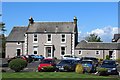
Temple House Care Home Ltd, Mossblown
First opened March 1991
Image: © Leslie Barrie
Taken: 13 May 2014
0.22 miles