IMAGES TAKEN NEAR TO
Gordon Street, MAUCHLINE, KA5 6PQ
Introduction
This page details the photographs taken nearby to Gordon Street, KA5 6PQ by members of the Geograph project.
The Geograph project started in 2005 with the aim of publishing, organising and preserving representative images for every square kilometre of Great Britain, Ireland and the Isle of Man.

There are currently over 7.5m images from over14,400 individuals and you can help contribute to the project by visiting https://www.geograph.org.uk
Image Map
Images are licensed for reuse under creativecommons.org/licenses/by-sa/2.0
Notes
- Clicking on the map will re-center to the selected point.
- The higher the marker number, the further away the image location is from the centre of the postcode.
Image Listing (32 Images Found)
Images are licensed for reuse under creativecommons.org/licenses/by-sa/2.0
Image
Details
Distance
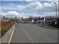
1
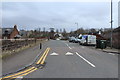
Site of Catrine station
View northward, terminus to the right, Mauchline to the left: ex-GSWR branch from Mauchline, closed for passengers 3/5/43, for goods 6/7/64. [The station was somewhre very near here!].
Image: © Ben Brooksbank
Taken: 21 Jun 1994
0.14 miles
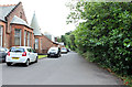
2
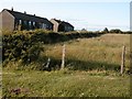
John Street, Catrine c 2004
Land earmarked for building.
Still vacant at time of submission 2012
Image: © Tom Morrison
Taken: 17 Jul 2004
0.17 miles
8
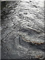
Flow patterns on the River Ayr, Catrine
Seen from the bridge.
Image: © Humphrey Bolton
Taken: 11 Oct 2017
0.21 miles
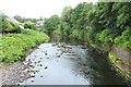
10
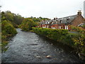
The River Ayr in Catrine
Looking upstream from the bridge.
Image: © Humphrey Bolton
Taken: 11 Oct 2017
0.23 miles