IMAGES TAKEN NEAR TO
Catrine, MAUCHLINE, KA5 6NJ
Introduction
This page details the photographs taken nearby to KA5 6NJ by members of the Geograph project.
The Geograph project started in 2005 with the aim of publishing, organising and preserving representative images for every square kilometre of Great Britain, Ireland and the Isle of Man.

There are currently over 7.5m images from over14,400 individuals and you can help contribute to the project by visiting https://www.geograph.org.uk
Image Map
Images are licensed for reuse under creativecommons.org/licenses/by-sa/2.0
Notes
- Clicking on the map will re-center to the selected point.
- The higher the marker number, the further away the image location is from the centre of the postcode.
Image Listing (3 Images Found)
Images are licensed for reuse under creativecommons.org/licenses/by-sa/2.0
Image
Details
Distance
1
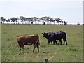
Cattle
Cattle in the fields by Bogend Farm
Image: © Angela Mudge
Taken: 19 Jul 2006
0.16 miles
2
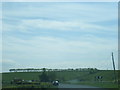
Bogend Farm
This farm is located just off the B705 road linking Catrine (NS5225) to Auchinleck (NS5521). There is a pedigree dairy herd of Friesian, Holstein cattle. Space is also provided near the farm for the parking of touring caravans.
Image: © Bob Forrest
Taken: 8 Mar 2007
0.22 miles