IMAGES TAKEN NEAR TO
Catrine, MAUCHLINE, KA5 6LW
Introduction
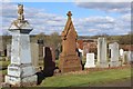
This page details the photographs taken nearby to KA5 6LW by members of the Geograph project.
The Geograph project started in 2005 with the aim of publishing, organising and preserving representative images for every square kilometre of Great Britain, Ireland and the Isle of Man.

There are currently over 7.5m images from over14,400 individuals and you can help contribute to the project by visiting https://www.geograph.org.uk
Image Map
Images are licensed for reuse under creativecommons.org/licenses/by-sa/2.0
Notes
- Clicking on the map will re-center to the selected point.
- The higher the marker number, the further away the image location is from the centre of the postcode.
Image Listing (4 Images Found)
Images are licensed for reuse under creativecommons.org/licenses/by-sa/2.0
Image
Details
Distance
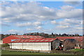
3
Shawwood Council Estate
A post-war council housing estate part of which is in the process of modernisation. The path of the former branch railway line from Mauchline can be seen in the middle distance.
Image: © Bob Forrest
Taken: 16 Jan 2007
0.15 miles