IMAGES TAKEN NEAR TO
MAUCHLINE, KA5 6JZ
Introduction
This page details the photographs taken nearby to KA5 6JZ by members of the Geograph project.
The Geograph project started in 2005 with the aim of publishing, organising and preserving representative images for every square kilometre of Great Britain, Ireland and the Isle of Man.

There are currently over 7.5m images from over14,400 individuals and you can help contribute to the project by visiting https://www.geograph.org.uk
Image Map
Images are licensed for reuse under creativecommons.org/licenses/by-sa/2.0
Notes
- Clicking on the map will re-center to the selected point.
- The higher the marker number, the further away the image location is from the centre of the postcode.
Image Listing (14 Images Found)
Images are licensed for reuse under creativecommons.org/licenses/by-sa/2.0
Image
Details
Distance
1
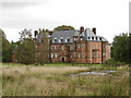
Ballochmyle House
Ballochmyle was part of the barony of Kylesmure which King William the Lion granted in the year 1165 to the Cistercian monks of Melrose Abbey. By the sixteenth century Ballochmyle had become a separate estate. In 1760, a "new House very neatly fitted up and finished" possibly designed by the famous architect William Adam, replaced the old tower house. Further extensions to the main building were made during the succeeding years, including the front portion. The architect of the front portion was H M Wardrop and the building was executed in red "Ballochmyle Stone" from the quarries in Mauchline. Wardrop was also the architect of the Station Hotel in Ayr which is built of the same stone. The extension of the house was finished in 1886. On the death of Sir Claud Alexander, the house was let from 1899 until 1937/38.
In 1938, arrangements were made to sell the house and policies to the Department of Health for use as a hospital. Entry was tacitly permitted that year and the missives were finally completed in October 1939, a month after the outbreak of war. Ballochmyle House and grounds were purchased by the Secretary of State in 1939 as a suitable site for one of the EMS (Emergency Medical Services) hospitals being built at that time in anticipation of war-time requirements. It was built on the pavilion plan following the standard plan of EMS hospitals. Initially there were two blocks of eight wards and a block containing the administrative office, the kitchen, laboratory and pharmacy and this part of the construction was completed by the Autumn of 1940. The mansion house was utilised as residential accommodation for the medical, nursing, administrative and technical staff. (Information from Northkirk Homes Ltd.)
The hospital buildings (mostly located in Grid Square Image ) were recently demolished, and the estate was being re-developed as an area of luxury housing. 94 Houses were planned but only 23 have been completed to date as, in April 2012 the developer went into administration, so building work is currently at a standstill. Ballochmyle House itself has been converted into nineteen apartments, eight of which have been sold.
Image: © Richard Dorrell
Taken: 28 Sep 2012
0.01 miles
2
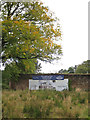
Maybe one day...
The large sign attached to the ancient wall surrounding the walled garden of Ballochmyle House states that new luxury housing will be built here soon. However, the developers went into administration in April 2012, so no new building is taking place here just yet. (See also Image] ).
Image: © Richard Dorrell
Taken: 28 Sep 2012
0.15 miles
3

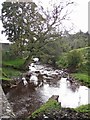
Burn o' Need / Ayr confluence
The Burn o' Need meets the River Ayr downstream of Catrine.
Image: © Richard Webb
Taken: 22 Apr 2017
0.20 miles
4
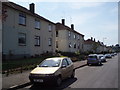
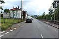
Mauchline Road
Council housing in Catrine
Image: © Angela Mudge
Taken: 19 Jul 2006
0.21 miles
5

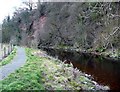
Sandstone crags, Ballochmyle
Crags above the River Ayr.
Image: © Richard Webb
Taken: 22 Apr 2017
0.21 miles
6
The Burn o' Need from Shellies Bridge
The bridge carries the Mauchline Road over the burn. The burn is a tributary of the River Ayr.
Image: © Richard Dorrell
Taken: 28 Sep 2012
0.21 miles
7
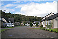
Burn o' Need Way
Houses on the left of this cul-de-sac in Catrine back onto the Burn o' Need.
Image: © Richard Dorrell
Taken: 28 Sep 2012
0.21 miles
10
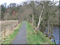
The River Ayr Way west of Catrine
Progressing downstream towards the gorge, the first cliffs can be seen on the far side.
Image: © Gordon Brown
Taken: 22 Mar 2008
0.23 miles