IMAGES TAKEN NEAR TO
Howford, MAUCHLINE, KA5 6JU
Introduction
This page details the photographs taken nearby to Howford, KA5 6JU by members of the Geograph project.
The Geograph project started in 2005 with the aim of publishing, organising and preserving representative images for every square kilometre of Great Britain, Ireland and the Isle of Man.

There are currently over 7.5m images from over14,400 individuals and you can help contribute to the project by visiting https://www.geograph.org.uk
Image Map
Images are licensed for reuse under creativecommons.org/licenses/by-sa/2.0
Notes
- Clicking on the map will re-center to the selected point.
- The higher the marker number, the further away the image location is from the centre of the postcode.
Image Listing (8 Images Found)
Images are licensed for reuse under creativecommons.org/licenses/by-sa/2.0
Image
Details
Distance
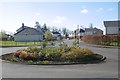
1
Where's the hospital?
This is the site of the old Ballochmyle Hospital closed in the '90s.
Image: © Angela Mudge
Taken: 19 Jul 2006
0.03 miles
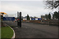
2
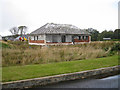
Unfinished luxury bungalow
This bungalow is one of the 94 luxury homes planned to be built on the land formerly occupied by Ballochmyle Hospital. However, only 23 of the homes have been built, and the developer went into administration in April 2012, so further building has stopped.
Image: © Richard Dorrell
Taken: 28 Sep 2012
0.04 miles
3
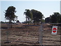
Coming soon? Possibly not
The location is a development of a large and luxurious houses and bungalows on the site of the former Ballochmyle Hospital, but only a few have been built, and in April 2012, the developer - Ardgowan Homes - went into administration. See also Image] .
Image: © Richard Dorrell
Taken: 28 Sep 2012
0.07 miles
4
Stalled development, Ballochmyle
The site of Ballochmyle Hospital which has partly developed for housing. Much of the site is still derelict after the developers became insolvent.
Image: © Richard Webb
Taken: 22 Apr 2017
0.09 miles
5
Ballochmyle, the finished bit
The site of Ballochmyle Hospital which has partly developed for housing. Much of the site is still derelict after the developers became insolvent, but this row was completed.
Image: © Richard Webb
Taken: 22 Apr 2017
0.10 miles
6
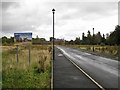
Former site of NHS Ballochmyle Hospital
The site of the former Ballochmyle hospital noted for its plastic surgery department during WW2 when it treated badly burned airmen. The site exits on to the B705 which leads to the villages of Catrine and Mauchline. The former hospital site is now being developed as a prestigious private housing development.
Image: © Bob Forrest
Taken: 21 Dec 2006
0.10 miles
7
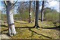
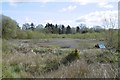
Strip wood, Ballochmyle
Beeches in the strip which surrounded the Ballochmyle policies. The estate became a hospital which gained a reputation for treating burns in wartime. Latterly it was developed as an upmarket housing scheme, but the development stalled after the banking collapse in 2008.
Image: © Richard Webb
Taken: 22 Apr 2017
0.13 miles
8
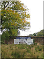
Maybe one day...
The large sign attached to the ancient wall surrounding the walled garden of Ballochmyle House states that new luxury housing will be built here soon. However, the developers went into administration in April 2012, so no new building is taking place here just yet. (See also Image] ).
Image: © Richard Dorrell
Taken: 28 Sep 2012
0.19 miles