IMAGES TAKEN NEAR TO
MAUCHLINE, KA5 6JG
Introduction
This page details the photographs taken nearby to KA5 6JG by members of the Geograph project.
The Geograph project started in 2005 with the aim of publishing, organising and preserving representative images for every square kilometre of Great Britain, Ireland and the Isle of Man.

There are currently over 7.5m images from over14,400 individuals and you can help contribute to the project by visiting https://www.geograph.org.uk
Image Map (Loading...)


Getting Data...Please wait
Leaflet Map data © OpenStreetMap
Images are licensed for reuse under creativecommons.org/licenses/by-sa/2.0
Notes
- Clicking on the map will re-center to the selected point.
- The higher the marker number, the further away the image location is from the centre of the postcode.
Image Listing (7 Images Found)
Images are licensed for reuse under creativecommons.org/licenses/by-sa/2.0
Image
Details
Distance
3
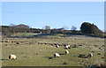
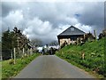
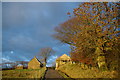
High Brocklar
Renovated farm house and steading with a garage/workshop located on the farm track leading to Blacksidend Farm and Blackside. There is a mixed plantation of conifers and deciduous trees behind the property and old gnarled deciduous trees provide a boundary between the well tended grass in front of the house and the rough grazing running down to the Cleuch Burn grazed by sheep. A line of relatively new trees to the right of the house has been planted to provide additional shelter from the SW winds.
Image: © Bob Forrest
Taken: 6 Feb 2007
0.01 miles