IMAGES TAKEN NEAR TO
Sorn, MAUCHLINE, KA5 6JF
Introduction
This page details the photographs taken nearby to KA5 6JF by members of the Geograph project.
The Geograph project started in 2005 with the aim of publishing, organising and preserving representative images for every square kilometre of Great Britain, Ireland and the Isle of Man.

There are currently over 7.5m images from over14,400 individuals and you can help contribute to the project by visiting https://www.geograph.org.uk
Image Map
Images are licensed for reuse under creativecommons.org/licenses/by-sa/2.0
Notes
- Clicking on the map will re-center to the selected point.
- The higher the marker number, the further away the image location is from the centre of the postcode.
Image Listing (3 Images Found)
Images are licensed for reuse under creativecommons.org/licenses/by-sa/2.0
Image
Details
Distance
2
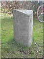
Old Milestone by the B743 near Nethershield Farm, Sorn Parish
Ayr granite milestone by the B743, in parish of Sorn (Kyle District), Nethershield Farm, at edge of wood near farm, which stands back from road.
Inscription reads:-
: Mauchline / 6 : : Muirkirk / 7½ :
Rivet benchmark on top.
Surveyed
Milestone Society National ID: AYE_AYMK17
Image: © Milestone Society
Taken: Unknown
0.04 miles