IMAGES TAKEN NEAR TO
Anderson Crescent, MAUCHLINE, KA5 6HX
Introduction
This page details the photographs taken nearby to Anderson Crescent, KA5 6HX by members of the Geograph project.
The Geograph project started in 2005 with the aim of publishing, organising and preserving representative images for every square kilometre of Great Britain, Ireland and the Isle of Man.

There are currently over 7.5m images from over14,400 individuals and you can help contribute to the project by visiting https://www.geograph.org.uk
Image Map
Images are licensed for reuse under creativecommons.org/licenses/by-sa/2.0
Notes
- Clicking on the map will re-center to the selected point.
- The higher the marker number, the further away the image location is from the centre of the postcode.
Image Listing (50 Images Found)
Images are licensed for reuse under creativecommons.org/licenses/by-sa/2.0
Image
Details
Distance
2
Commercial premises, Main Street, Sorn
No board on the premises to say what the business is, but there is a sign for MOT tests. Unfortunately the search engine can't distinguish between Sorn and SORN, and Sorn does not seem to be an essential part of the postal address, but eventually I found that this is the premises of J D Morton & Son,
Motorcycle Dealers.
Image: © Humphrey Bolton
Taken: 11 Oct 2017
0.10 miles

5
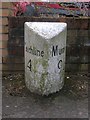
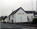
Old Milestone by the B743, Main Street, Sorn
Ayr granite by the B743, in parish of Sorn (Kyle District), Sorn, opposite Sorn Inn.
Inscriptiuon reads:- : MAUCHLINE / 4 : : MUIRKIRK / 9½ :
Surveyed
Milestone Society National ID: AYE_AYMK15.
Image: © Milestone Society
Taken: Unknown
0.15 miles
6

George Wood's Memorial
Memorial for the Covenanter George Wood.
Image: © Rab McMurdo
Taken: 13 Jul 2021
0.15 miles
7
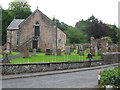
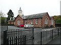
Sorn Parish Church
Originally built in 1658, Sorn Parish Church was reconstructed in 1826 and further improvements were made in 1910. It is located very close to Sorn Old Bridge and is a Category B listed building. https://www.britishlistedbuildings.co.uk/200347572-sorn-parish-church-sorn#.WZyE7DGWw5s
Image: © G Laird
Taken: 22 Aug 2017
0.16 miles
8
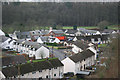
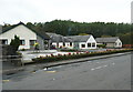
Council Housing
A crescent of council built houses from the mid 1950 period located back from the main street in Sorn. The building with the cream coloured tower is the primary school, built in 1850 and still in use to-day. Opposite the school and fitting in with the concept of a conservation village, are local authority housing reminiscent of the traditional thatched cottages which once occupied this part of Sorn, or Dalgain, which was the original name for the village.
Image: © Bob Forrest
Taken: 2 Feb 2007
0.16 miles
9
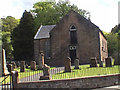
Sorn Church
Church on road between village and Sorn Castle.
Image: © John M
Taken: 30 May 2005
0.16 miles
10
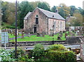
Church, Sorn
The church was originally built in 1658 and reconstructed in 1826. The outside stairs lead to three galleries. (Information from https://scotlandschurchestrust.org.uk/church/sorn-parish-church/ ).
Image: © Humphrey Bolton
Taken: 11 Oct 2017
0.16 miles