IMAGES TAKEN NEAR TO
MAUCHLINE, KA5 6HQ
Introduction
This page details the photographs taken nearby to KA5 6HQ by members of the Geograph project.
The Geograph project started in 2005 with the aim of publishing, organising and preserving representative images for every square kilometre of Great Britain, Ireland and the Isle of Man.

There are currently over 7.5m images from over14,400 individuals and you can help contribute to the project by visiting https://www.geograph.org.uk
Image Map (Loading...)


Getting Data...Please wait
Leaflet Map data © OpenStreetMap
Images are licensed for reuse under creativecommons.org/licenses/by-sa/2.0
Notes
- Clicking on the map will re-center to the selected point.
- The higher the marker number, the further away the image location is from the centre of the postcode.
Image Listing (9 Images Found)
Images are licensed for reuse under creativecommons.org/licenses/by-sa/2.0
Image
Details
Distance
1
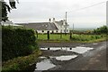
Modernised Rural Dwelling House
One of a small group of buildings known as Oxenshaw Terrace. These may have provided homes in the past for farm workers on nearby Oxenshaw Farm.
Image: © Bob Forrest
Taken: 22 Jan 2007
0.02 miles
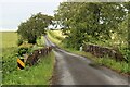
3
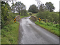
Oxenshaw Bridge
The narrow bridge carries an unclassified road over Cessnock Water.
Image: © Richard Dorrell
Taken: 28 Sep 2012
0.05 miles
4
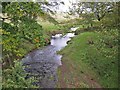
Cessnock Water
Looking upstream from the Oxenshaw Bridge.
Image: © Richard Dorrell
Taken: 28 Sep 2012
0.07 miles
5
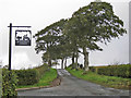
Entrance to Garfield Farm
The farm sign features a cut-out silhouette of a farmer and his dog on a quad bike, towing a trailer. Farm dogs seem to love riding on quad bikes. The farm entrance is on the left. The public road passes between the trees, which are beech.
Image: © Richard Dorrell
Taken: 28 Sep 2012
0.20 miles
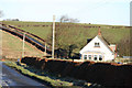
7
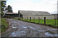
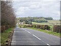
Barns at West Montgarswood farm
The muddy track is the result of a long, wet spell of weather.
Image: © Richard Dorrell
Taken: 28 Sep 2012
0.21 miles