IMAGES TAKEN NEAR TO
MAUCHLINE, KA5 6HN
Introduction
This page details the photographs taken nearby to KA5 6HN by members of the Geograph project.
The Geograph project started in 2005 with the aim of publishing, organising and preserving representative images for every square kilometre of Great Britain, Ireland and the Isle of Man.

There are currently over 7.5m images from over14,400 individuals and you can help contribute to the project by visiting https://www.geograph.org.uk
Image Map
Images are licensed for reuse under creativecommons.org/licenses/by-sa/2.0
Notes
- Clicking on the map will re-center to the selected point.
- The higher the marker number, the further away the image location is from the centre of the postcode.
Image Listing (4 Images Found)
Images are licensed for reuse under creativecommons.org/licenses/by-sa/2.0
Image
Details
Distance
2
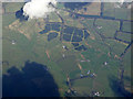
Cessnock Water and Burn o' Need from the air
Running through farmland between Catrine and Mauchline. Cessnock Water is in the centre, Burn o' Need is on the right.
Image: © Thomas Nugent
Taken: 17 Apr 2017
0.22 miles
3
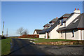
Redgate
Redgate is the centre of a small collection of new build private houses in a commanding location overlooking the local farming landscape. Redgate itself looks to be a converted farm house.
Image: © Bob Forrest
Taken: 22 Jan 2007
0.24 miles
4
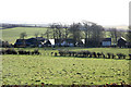
Dairy Farm
Farm located on the side of the B743 from Mauchline to Sorn. Sheep are also grazed near the farm in winter.
Image: © Bob Forrest
Taken: 22 Jan 2007
0.24 miles