IMAGES TAKEN NEAR TO
MAUCHLINE, KA5 6HD
Introduction
This page details the photographs taken nearby to KA5 6HD by members of the Geograph project.
The Geograph project started in 2005 with the aim of publishing, organising and preserving representative images for every square kilometre of Great Britain, Ireland and the Isle of Man.

There are currently over 7.5m images from over14,400 individuals and you can help contribute to the project by visiting https://www.geograph.org.uk
Image Map
Images are licensed for reuse under creativecommons.org/licenses/by-sa/2.0
Notes
- Clicking on the map will re-center to the selected point.
- The higher the marker number, the further away the image location is from the centre of the postcode.
Image Listing (5 Images Found)
Images are licensed for reuse under creativecommons.org/licenses/by-sa/2.0
Image
Details
Distance
4
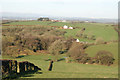
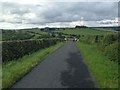
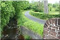
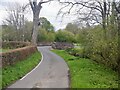
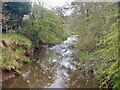
Auchmillan Land Use
Deciduous woodland and improved grassland leading down to the Auchmannoch Burn near Auchmillan from the minor road linking the farms in this area to the B7037 running from Galston to Sorn.
Image: © Bob Forrest
Taken: 22 Jan 2007
0.08 miles