IMAGES TAKEN NEAR TO
Alexander Terrace, MAUCHLINE, KA5 6AU
Introduction
This page details the photographs taken nearby to Alexander Terrace, KA5 6AU by members of the Geograph project.
The Geograph project started in 2005 with the aim of publishing, organising and preserving representative images for every square kilometre of Great Britain, Ireland and the Isle of Man.

There are currently over 7.5m images from over14,400 individuals and you can help contribute to the project by visiting https://www.geograph.org.uk
Image Map
Images are licensed for reuse under creativecommons.org/licenses/by-sa/2.0
Notes
- Clicking on the map will re-center to the selected point.
- The higher the marker number, the further away the image location is from the centre of the postcode.
Image Listing (13 Images Found)
Images are licensed for reuse under creativecommons.org/licenses/by-sa/2.0
Image
Details
Distance
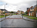
1
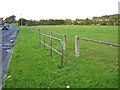
Entrance to a play area in Mauchline
The play area lies alongside Alexander Terrace, and users of the field are protected from running into the road by a single rail. A lack of wear on the grass suggests that this pedestrian entrance (opposite Auld Avenue) is little used.
Image: © Richard Dorrell
Taken: 28 Sep 2012
0.02 miles
2
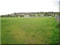
Mauchline play area
Viewed from an entrance from the end of Welton Road, this play area includes a football pitch and a play park with fixed equipment.
Image: © Richard Dorrell
Taken: 28 Sep 2012
0.03 miles
3
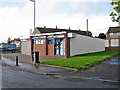
Auld Avenue Stores
A typical 'corner shop' (but this one not actually on a corner) serving the residents in the housing estate in east Mauchline.
Image: © Richard Dorrell
Taken: 28 Sep 2012
0.03 miles
4
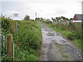
Track to West Welton farmhouse, Mauchline
The track leads out of Welton Road, within a housing estate.
Image: © Richard Dorrell
Taken: 28 Sep 2012
0.07 miles
5
Fernlea Avenue, Mauchline
Part of a modern housing development on the east of Mauchline, looking every bit as anonymous as many other modern housing developments in the UK. This view is taken looking north east, with the entrance to Anderson Avenue on the right.
Image: © Richard Dorrell
Taken: 28 Sep 2012
0.08 miles
6
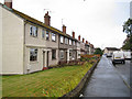
Lochlea Avenue, Mauchline
An area of modest terraced housing in the south eastern quarter of the small town.
Image: © Richard Dorrell
Taken: 28 Sep 2012
0.15 miles
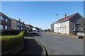
7
Hamilton Avenue post box
Looking north east from the junction with Donaldson Crescent.
Image: © Richard Dorrell
Taken: 28 Sep 2012
0.18 miles
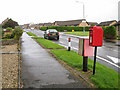
9
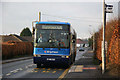
Bus link along the B705
The area is served by bus links from Cumnock to Ayr, Kilmarnock and Glasgow. While the service is adequate at peak travelling times, people without cars do find problems when travelling in the early morning and in the evenings.
Image: © Bob Forrest
Taken: 21 Dec 2006
0.22 miles
10
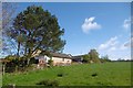
Fernlea Avenue
The edge of Mauchline, from the B705.
Image: © Richard Webb
Taken: 22 Apr 2017
0.23 miles