IMAGES TAKEN NEAR TO
Sorn Road, MAUCHLINE, KA5 6AP
Introduction
This page details the photographs taken nearby to Sorn Road, KA5 6AP by members of the Geograph project.
The Geograph project started in 2005 with the aim of publishing, organising and preserving representative images for every square kilometre of Great Britain, Ireland and the Isle of Man.

There are currently over 7.5m images from over14,400 individuals and you can help contribute to the project by visiting https://www.geograph.org.uk
Image Map
Images are licensed for reuse under creativecommons.org/licenses/by-sa/2.0
Notes
- Clicking on the map will re-center to the selected point.
- The higher the marker number, the further away the image location is from the centre of the postcode.
Image Listing (7 Images Found)
Images are licensed for reuse under creativecommons.org/licenses/by-sa/2.0
Image
Details
Distance
2
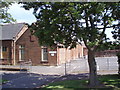
Mauchline Primary School
Entrance to the school
Image: © Angela Mudge
Taken: 19 Jul 2006
0.14 miles
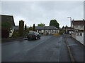
4
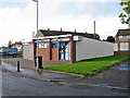
Auld Avenue Stores
A typical 'corner shop' (but this one not actually on a corner) serving the residents in the housing estate in east Mauchline.
Image: © Richard Dorrell
Taken: 28 Sep 2012
0.20 miles
5
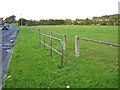
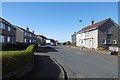
Entrance to a play area in Mauchline
The play area lies alongside Alexander Terrace, and users of the field are protected from running into the road by a single rail. A lack of wear on the grass suggests that this pedestrian entrance (opposite Auld Avenue) is little used.
Image: © Richard Dorrell
Taken: 28 Sep 2012
0.20 miles
6
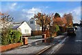
Glebe Avenue, Mauchline
The road ahead is now blocked to motorists.
Image: © JThomas
Taken: 21 May 2021
0.23 miles
7
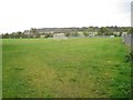
Mauchline play area
Viewed from an entrance from the end of Welton Road, this play area includes a football pitch and a play park with fixed equipment.
Image: © Richard Dorrell
Taken: 28 Sep 2012
0.24 miles