IMAGES TAKEN NEAR TO
Mansefield Road, MAUCHLINE, KA5 5RJ
Introduction
This page details the photographs taken nearby to Mansefield Road, KA5 5RJ by members of the Geograph project.
The Geograph project started in 2005 with the aim of publishing, organising and preserving representative images for every square kilometre of Great Britain, Ireland and the Isle of Man.

There are currently over 7.5m images from over14,400 individuals and you can help contribute to the project by visiting https://www.geograph.org.uk
Image Map
Images are licensed for reuse under creativecommons.org/licenses/by-sa/2.0
Notes
- Clicking on the map will re-center to the selected point.
- The higher the marker number, the further away the image location is from the centre of the postcode.
Image Listing (2 Images Found)
Images are licensed for reuse under creativecommons.org/licenses/by-sa/2.0
Image
Details
Distance
2
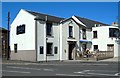
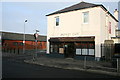
The Black Bull, Tarbolton
This traditional old hotel was built around 1822. Customers were outside, enjoying the spring sunshine when this shot was taken.
Image: © Mary and Angus Hogg
Taken: 12 May 2009
0.25 miles