IMAGES TAKEN NEAR TO
Yett, MAUCHLINE, KA5 5NU
Introduction
This page details the photographs taken nearby to Yett, KA5 5NU by members of the Geograph project.
The Geograph project started in 2005 with the aim of publishing, organising and preserving representative images for every square kilometre of Great Britain, Ireland and the Isle of Man.

There are currently over 7.5m images from over14,400 individuals and you can help contribute to the project by visiting https://www.geograph.org.uk
Image Map
Images are licensed for reuse under creativecommons.org/licenses/by-sa/2.0
Notes
- Clicking on the map will re-center to the selected point.
- The higher the marker number, the further away the image location is from the centre of the postcode.
Image Listing (5 Images Found)
Images are licensed for reuse under creativecommons.org/licenses/by-sa/2.0
Image
Details
Distance
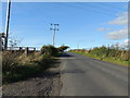
1
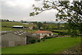
Farmland near Stair, Ayrshire
Farmland on the B730 near Stair in Ayrshire.
Image: © L J Cunningham
Taken: 5 Oct 2005
0.04 miles
2
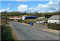
Yett and Wellflat Smallholdings
A springtime view taken on the B730 near Stair.
Image: © Mary and Angus Hogg
Taken: 14 Apr 2021
0.09 miles
3
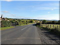
The B730 near Midton
In the direction of Stair.
Image: © Billy McCrorie
Taken: 7 Oct 2012
0.15 miles
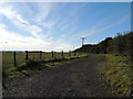
5
The B730 near Midton
In the direction of Tarbolton.
Image: © Billy McCrorie
Taken: 7 Oct 2012
0.17 miles