IMAGES TAKEN NEAR TO
Tarbolton, MAUCHLINE, KA5 5NE
Introduction
This page details the photographs taken nearby to KA5 5NE by members of the Geograph project.
The Geograph project started in 2005 with the aim of publishing, organising and preserving representative images for every square kilometre of Great Britain, Ireland and the Isle of Man.

There are currently over 7.5m images from over14,400 individuals and you can help contribute to the project by visiting https://www.geograph.org.uk
Image Map
Images are licensed for reuse under creativecommons.org/licenses/by-sa/2.0
Notes
- Clicking on the map will re-center to the selected point.
- The higher the marker number, the further away the image location is from the centre of the postcode.
Image Listing (8 Images Found)
Images are licensed for reuse under creativecommons.org/licenses/by-sa/2.0
Image
Details
Distance
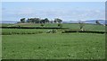
2
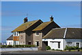
Bourtreebush Farmhouse
This is the point on the A719 when travelling towards Ayr that you can get a first glimpse of the Firth of Clyde, which can here be seen in the distance.
Image: © G Laird
Taken: 24 Aug 2008
0.02 miles
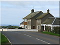
3
Bourtreebush Farm
Nice green grass for this time of year.
Image: © wfmillar
Taken: 16 Feb 2007
0.06 miles
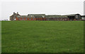
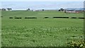
5
Grass near Brownhill
Grass for the local dairy industry which appears to be moving indoors.
Image: © Richard Webb
Taken: 21 May 2013
0.13 miles
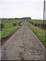
6
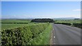
A719
Ayr to Galston road running through dairy farming country. Not many cows visible though.
Image: © Richard Webb
Taken: 21 May 2013
0.17 miles
8
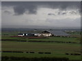
Brownhill Farm, Tarbolton
Very large shed being erected at Brownhill Farm Tarbolton
Image: © Alex Scott
Taken: 4 May 2009
0.25 miles