IMAGES TAKEN NEAR TO
Trabboch, MAUCHLINE, KA5 5HZ
Introduction
This page details the photographs taken nearby to KA5 5HZ by members of the Geograph project.
The Geograph project started in 2005 with the aim of publishing, organising and preserving representative images for every square kilometre of Great Britain, Ireland and the Isle of Man.

There are currently over 7.5m images from over14,400 individuals and you can help contribute to the project by visiting https://www.geograph.org.uk
Image Map
Images are licensed for reuse under creativecommons.org/licenses/by-sa/2.0
Notes
- Clicking on the map will re-center to the selected point.
- The higher the marker number, the further away the image location is from the centre of the postcode.
Image Listing (19 Images Found)
Images are licensed for reuse under creativecommons.org/licenses/by-sa/2.0
Image
Details
Distance

6
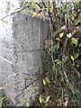
Old Guide Stone by the B730 at Schaw
Square granite by the B730, in parish of Ochiltree (Kyle District), Schaw, junction with UC road to Mauchline.
Surveyed
Milestone Society National ID: AYE_IRLMsw
Image: © Milestone Society
Taken: Unknown
0.15 miles
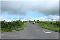
8
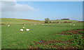
Ayrshire Farmland
Grazing land on Ayrshire's glacial drumlins.
Image: © Mary and Angus Hogg
Taken: 22 Oct 2015
0.16 miles
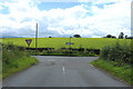
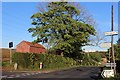
10
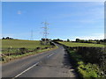
The B730 near Loudonston
In the direction of Coalhall.
Image: © Billy McCrorie
Taken: 7 Oct 2012
0.17 miles