IMAGES TAKEN NEAR TO
MAUCHLINE, KA5 5HQ
Introduction
This page details the photographs taken nearby to KA5 5HQ by members of the Geograph project.
The Geograph project started in 2005 with the aim of publishing, organising and preserving representative images for every square kilometre of Great Britain, Ireland and the Isle of Man.

There are currently over 7.5m images from over14,400 individuals and you can help contribute to the project by visiting https://www.geograph.org.uk
Image Map
Images are licensed for reuse under creativecommons.org/licenses/by-sa/2.0
Notes
- Clicking on the map will re-center to the selected point.
- The higher the marker number, the further away the image location is from the centre of the postcode.
Image Listing (19 Images Found)
Images are licensed for reuse under creativecommons.org/licenses/by-sa/2.0
Image
Details
Distance
1
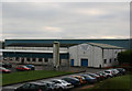
Cheese Packing Factory
This was formerly a Scottish Milk Marketing Board creamery which was the collection centre for milk from the local dairy farms. It used this milk for a large number of dairy manufacturing processes e.g. butter making. Due to the restructuring of the Milk Marketing Board activities in south west Scotland and a reduction in the volume of milk produced locally, a number of these manufacturing processes have been lost to the factory, leaving cheese packing as the main activity.
Image: © Bob Forrest
Taken: 5 Jan 2007
0.04 miles
2
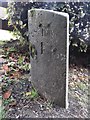
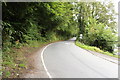
Old Milestone by Barskimming Road, Mauchline Parish
Ayr granite by the UC road, in parish of Mauchline (Kyle District), South of cemetery, outside Bentfield.
Inscription reads:- : Schaw / 4¾ : : Mauchline / 1 :
Surveyed
Milestone Society National ID: AYE_MCSW01
Image: © Milestone Society
Taken: Unknown
0.08 miles
3
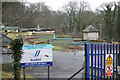
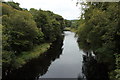
Water Treatment Works
The Barskimming Water Treatment Works occupies part of the floodplain of the R.Ayr to which it is adjacent. There is a small outfall from the works into the R.Ayr just to the east of Barskimming road bridge which can be seen in the photograph of the bridge.
Image: © Bob Forrest
Taken: 5 Jan 2007
0.12 miles
4
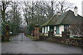
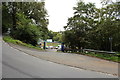
Northeast Lodge
Lodge and drive leading to Barskimming House (NS4825) which is still occupied. The river Ayr runs through a wooded gorge which is part of this estate. In the summer the estate hosts the Barskimming Horse Trials.
Image: © Bob Forrest
Taken: 5 Jan 2007
0.14 miles
6
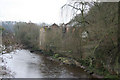
Ruined Mill
A former mill making use of the water power provided by the R. Ayr. Now abandoned and in a very poor state of repair.
Image: © Bob Forrest
Taken: 5 Jan 2007
0.16 miles
7
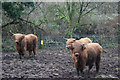
Highland Cattle
After the heavy December rain this normally grass covered field has become badly poached by this small herd of highland cattle.
Image: © Bob Forrest
Taken: 23 Dec 2006
0.17 miles
10
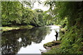
River Ayr near Mauchline
With a lone fisherman.
Image: © Billy McCrorie
Taken: 2 Sep 2014
0.18 miles