IMAGES TAKEN NEAR TO
MAUCHLINE, KA5 5HE
Introduction
This page details the photographs taken nearby to KA5 5HE by members of the Geograph project.
The Geograph project started in 2005 with the aim of publishing, organising and preserving representative images for every square kilometre of Great Britain, Ireland and the Isle of Man.

There are currently over 7.5m images from over14,400 individuals and you can help contribute to the project by visiting https://www.geograph.org.uk
Image Map
Images are licensed for reuse under creativecommons.org/licenses/by-sa/2.0
Notes
- Clicking on the map will re-center to the selected point.
- The higher the marker number, the further away the image location is from the centre of the postcode.
Image Listing (2 Images Found)
Images are licensed for reuse under creativecommons.org/licenses/by-sa/2.0
Image
Details
Distance
2
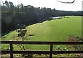
Netheraird Holm
The view from a vantage point above the caves.
The image clearly shows the raised floodplain of the river, and also the terrace effect in the foreground arising from lowered water levels following the subsidence of riverwater after the last ice age.
Looking downstream, the far bank of the river (in shade) consists of sandstone cliffs and steeply wooded slopes.
Nowadays, when in full spate, the river is unlikely to rise enough to reach the gorse bushes visible along the right hand banking.
Image: © Stuart Brabbs
Taken: 12 May 2007
0.20 miles