IMAGES TAKEN NEAR TO
West Park Avenue, MAUCHLINE, KA5 5DY
Introduction
This page details the photographs taken nearby to West Park Avenue, KA5 5DY by members of the Geograph project.
The Geograph project started in 2005 with the aim of publishing, organising and preserving representative images for every square kilometre of Great Britain, Ireland and the Isle of Man.

There are currently over 7.5m images from over14,400 individuals and you can help contribute to the project by visiting https://www.geograph.org.uk
Image Map
Images are licensed for reuse under creativecommons.org/licenses/by-sa/2.0
Notes
- Clicking on the map will re-center to the selected point.
- The higher the marker number, the further away the image location is from the centre of the postcode.
Image Listing (97 Images Found)
Images are licensed for reuse under creativecommons.org/licenses/by-sa/2.0
Image
Details
Distance
1
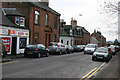
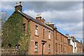
Residential housing
Leaving Mauchline to the south west along the B734, there is a mixture of red sandstone terraced housing and newer private housing areas.
Image: © Bob Forrest
Taken: 23 Dec 2006
0.07 miles
2
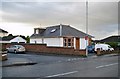
Unusual B&B
What appears at first glance to be a small suburban bungalow on the corner of West Park Avenue, Mauchline, has a large first floor extension to the rear which provides comfortable and spacious bed and breakfast accommodation.
Image: © Richard Dorrell
Taken: 29 Sep 2012
0.08 miles
3
Westside Gardens, Mauchline
A small cul-de-sac of bungalows off the Ayr Road.
Image: © Richard Dorrell
Taken: 29 Sep 2012
0.10 miles
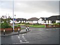
4
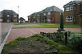
Council Housing
A council housing area dating from around the 1950 period which lies between Barskimming Road and the B743. It lies behind older red sandstone terraced cottages and semi detached villas.
Image: © Bob Forrest
Taken: 23 Dec 2006
0.10 miles
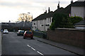
6
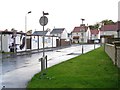
Loudoun Street, Mauchline
This is the main shopping area in the village and is part of the B743 which links Mauchline to the town of Ayr. Traffic congestion can be a problem in what is one of the original streets in the village.
Image: © Bob Forrest
Taken: 23 Dec 2006
0.12 miles
7
New housing development, Mauchline
Named Netherplace, after the mansion house which once stood nearby (demolished in the 1960s) this modern housing development of 38 three and four-bedroom detached houses and bungalows is nearing completion.
Image: © Richard Dorrell
Taken: 29 Sep 2012
0.13 miles
8
High class residential housing
A new residential housing development only completed in the latter part of 2006 on land formerly used for agriculture and an agricultural engineering works.
Image: © Bob Forrest
Taken: 21 Dec 2006
0.13 miles
9
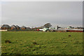
Poultry Farm and land scheduled for private housing
A poultry farm selling eggs, but which also reared ostriches. The rear of the high class residential housing seen in photograph 296797 can be seen to the left of the farm. The farm and the land in the foreground is likely to be sold for the development of more residential housing.
Image: © Bob Forrest
Taken: 21 Dec 2006
0.13 miles
10
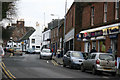
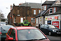
Loudon Street shops
The village is well provided with a variety of shops. 2 of the three main supermarkets are found here. There is also a family butcher, chemist, photographer, hardware store, sports shop, hair salon, tearoom/baker, greengrocer, a fashion and clothing shop as well as the Post Office and Newsagent.
Image: © Bob Forrest
Taken: 23 Dec 2006
0.15 miles