IMAGES TAKEN NEAR TO
Tower Way, KA5 5DN
Introduction
This page details the photographs taken nearby to Tower Way, KA5 5DN by members of the Geograph project.
The Geograph project started in 2005 with the aim of publishing, organising and preserving representative images for every square kilometre of Great Britain, Ireland and the Isle of Man.

There are currently over 7.5m images from over14,400 individuals and you can help contribute to the project by visiting https://www.geograph.org.uk
Image Map
Images are licensed for reuse under creativecommons.org/licenses/by-sa/2.0
Notes
- Clicking on the map will re-center to the selected point.
- The higher the marker number, the further away the image location is from the centre of the postcode.
Image Listing (50 Images Found)
Images are licensed for reuse under creativecommons.org/licenses/by-sa/2.0
Image
Details
Distance
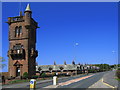
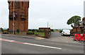
8
Road beside National Burns Memorial, Mauchline
Showing position of Postbox No. KA5 152.
Image: © JThomas
Taken: 21 May 2021
0.12 miles
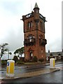
9
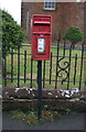
Elizabethan postbox, National Burns Memorial, Mauchline
Postbox No. KA5 152.
Image: © JThomas
Taken: 21 May 2021
0.12 miles
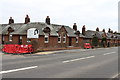
10
Local Road in Mauchline
Next to Burns Memorial.
Image: © Billy McCrorie
Taken: 2 Sep 2014
0.12 miles