IMAGES TAKEN NEAR TO
Carrick View, MAUCHLINE, KA5 5DH
Introduction
This page details the photographs taken nearby to Carrick View, KA5 5DH by members of the Geograph project.
The Geograph project started in 2005 with the aim of publishing, organising and preserving representative images for every square kilometre of Great Britain, Ireland and the Isle of Man.

There are currently over 7.5m images from over14,400 individuals and you can help contribute to the project by visiting https://www.geograph.org.uk
Image Map
Images are licensed for reuse under creativecommons.org/licenses/by-sa/2.0
Notes
- Clicking on the map will re-center to the selected point.
- The higher the marker number, the further away the image location is from the centre of the postcode.
Image Listing (47 Images Found)
Images are licensed for reuse under creativecommons.org/licenses/by-sa/2.0
Image
Details
Distance
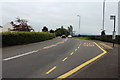
3
Dumfries 51 Miles
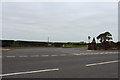
The A76 through Mauchline.
Image: © JThomas
Taken: 21 May 2021
0.04 miles
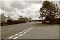
6
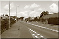
Kilmarnock Road, Mauchline
At the Burns Memorial.
Image: © Billy McCrorie
Taken: 2 Sep 2014
0.05 miles
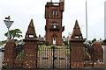
9
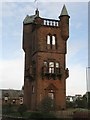
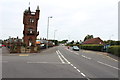
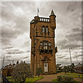
National Burns Memorial, Mauchline
The Burns Tower as it is known locally, has been closed to the public for many years, except for some special events. In the past though, the tower was used as a museum.
Image: © G Laird
Taken: 27 Oct 2015
0.06 miles