IMAGES TAKEN NEAR TO
Auchencloigh, GALSTON, KA4 8NP
Introduction
This page details the photographs taken nearby to Auchencloigh, KA4 8NP by members of the Geograph project.
The Geograph project started in 2005 with the aim of publishing, organising and preserving representative images for every square kilometre of Great Britain, Ireland and the Isle of Man.

There are currently over 7.5m images from over14,400 individuals and you can help contribute to the project by visiting https://www.geograph.org.uk
Image Map
Images are licensed for reuse under creativecommons.org/licenses/by-sa/2.0
Notes
- Clicking on the map will re-center to the selected point.
- The higher the marker number, the further away the image location is from the centre of the postcode.
Image Listing (4 Images Found)
Images are licensed for reuse under creativecommons.org/licenses/by-sa/2.0
Image
Details
Distance
1

Remains of an old kiln at Auchencloigh
The remains of this kiln are in a private garden. This photo was taken from just outside the gates of the property.
Image: © Rab McMurdo
Taken: 13 Jul 2021
0.09 miles
2
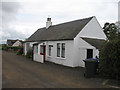
The Old School House, Auchencloigh
This cottage was the School House for the long-demolished single-teacher school at Auchencloigh, which stood across the road from the house. It was my first home in the later years of the Second World War, long before electricity had reached that part of Ayrshire.
Image: © Lee Davidson
Taken: 15 Jun 2011
0.24 miles