IMAGES TAKEN NEAR TO
GALSTON, KA4 8LF
Introduction
This page details the photographs taken nearby to KA4 8LF by members of the Geograph project.
The Geograph project started in 2005 with the aim of publishing, organising and preserving representative images for every square kilometre of Great Britain, Ireland and the Isle of Man.

There are currently over 7.5m images from over14,400 individuals and you can help contribute to the project by visiting https://www.geograph.org.uk
Image Map
Images are licensed for reuse under creativecommons.org/licenses/by-sa/2.0
Notes
- Clicking on the map will re-center to the selected point.
- The higher the marker number, the further away the image location is from the centre of the postcode.
Image Listing (9 Images Found)
Images are licensed for reuse under creativecommons.org/licenses/by-sa/2.0
Image
Details
Distance
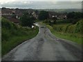
4
The Chris Hoy Cycle Way
Follows the dismantled railway from Galston to Hurlford
Image: © Leslie Barrie
Taken: 31 May 2014
0.16 miles
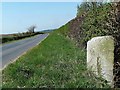
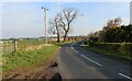
6
Milestone on the B744
Tarbolton and Coylton milestone on the B744 one mile from Galston.
Image: © Raibeart MacAoidh
Taken: 21 Apr 2019
0.20 miles
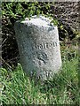
7
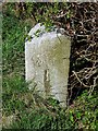
Milestone on the B744
Milestone on the B744 one mile from Galston.
Image: © Raibeart MacAoidh
Taken: 21 Apr 2019
0.20 miles
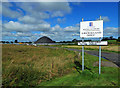
8
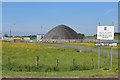
East Ayrshire Council Roads & Transport, Gauchalland Depot
Image: © Leslie Barrie
Taken: 31 May 2014
0.21 miles
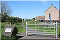
9
Gauchalland Depot
Operated at Galston by East Ayrshire Council.
Image: © Mary and Angus Hogg
Taken: 8 Aug 2020
0.22 miles